Protecting the Medway Catchment
The Water Framework Directive is a Europe wide scheme initiated in 2003 aiming to improve the ecological status of the entire water environment. Read more about it here. To enact this across Kent, the Environment Agency has established a whole series of river catchment co-ordinators to plan, progress and manage a huge range of projects with a plethora of partners. These projects will be encompassed by Catchment Improvement Groups (CIG) specific to areas within the wider river catchment.
MVCP and the South East Rivers Trust will be playing a leading role in helping to implement ecological improvements on the ground. To find out more about the Middle Medway and Beult sub-catchments please explore this page.
Middle Medway Catchment Information
Location & Geology
The Middle Medway operational catchment covers an area of 455.94km sq from Tonbridge to Allington Lock and comprises of the Medway navigation, Alder Stream, Bid Stream, River Bourne, Ditton Stream, Hilden Brook, River Len, Leybourne Stream, Loose Stream, Mereworth Stream, Penn Stream and Tudeley Brook. For the purpose of this plan the Medway navigational catchment is management by the River Medway Alliance and the tributaries of the Medway are covered by this plan.
The catchment is a mixture of urban and rural landscapes, land use is predominantly soft fruit, orchards and hops between Maidstone and Tonbridge; whilst arable farming dominates the flatter land particularly in the floodplain.
The catchment has helped shape many of the towns and villages which the rivers and streams pass through. A legacy of mills is still evident from the small channels which split flows and the mill ponds, weirs and sluice which impound and divert most of the waterbodies across the catchment.
Hydrology
The catchment lies 150-200m above sea level with the water bodies obtaining flows from a mixed geology. Within the upper reaches of the catchment the east west band of Weald Clay has been overlain with alluvium and river terraces, the variability in bedrock results in different permeability with some areas heavily drained and other areas being relatively dry. As a result surface water plays a significant role in the Medway drainage.
Within the middle reaches of the catchment the junction between the Folkestone beds and clayey Sandgate beds gives rise to springs, in addition the highly fractured nature of the Hythe Beds and geological layer add to the spring flow.
The lower reaches of the catchment are characterised by Ardingly Sandstone with lower Tunbridge Wells Sands, the streams within this area have cut through these layers exposing the Wadhurst Clay. Consequently, there are many springs which coalesce to from the many streams.
Habitats & species
The catchment has high conservation potential but has experienced a long history of modification in order to sustain human activity, resulting in a catchment which has few truly natural stretches and is divorced from its floodplain. Numerous historic mill structures and many smaller impoundments are evident throughout the catchment; these pose an obstacle to migration of coarse and salmonid fish species. These structures can also result in the accumulation of silt in the impounded waters behind a structure. Both the obstruction and habitat change have consequences for river wildlife.
Habitat for wildlife varies significantly throughout the course of the catchment with good habitat disconnected by reaches of poorer quality. This is due to the impact of the many structures, and the restriction of natural hydromorphology interactions within each river. Historic land drainage practices, where natural bed material has been removed from the watercourse, has also impacted in some locations.
Non-native invasive flora species include Himalayan Balsam, Giant Hogweed, Japanese Knotweed and Floating Pennywort, non-native invasive fauna species include Mitten Crab, Signal Crayfish and Mink all of which have consequential impacts on river habitat and species.
Changing land practices within the catchment and intensive farming, highways and industry adjacent to the river can cause significant increase in the presence of silt within the river system. Diffuse pollution, surface run-off and point source pollution can be a significant risk to river habitat and a pollution incident can be damaging to both the habitat and associated species.
Important habitats:
Lowland meadows – is characterised by species rich neutral grassland, this habitat supports a rich diversity of grasses and floral species and are important for amphibians, small mammals such as bats and birds such as barn owls. Factors affecting the habitat include intensive farming practices, reduced livestock grazing and lack of appropriate management.
Native woodland and Wet woodland – are characterised by broadleaved species, these habitat support a rich diversity of invertebrates, birds, bats and both small and large mammals. Woodland sites often comprise a range of ‘micro’ habitat types; dry woodland, wet woodland and dead wood all of which can support specialist priority species.
Standing open water – provides habitat for a variety of threatened flora and fauna, notable species include the great crested newt and water vole. The catchment supports a relatively large proportion of standing water and is rich in ponds, meres and lakes. Factors affecting the habitat include water quality, intensive management and sedimentation.
Priority species:
Anguilla anguilla (European eel) – Critically endangered, IUCN Red List of Threatened Species;
Arvicola terrestris (Watervole) – UKBAP Priority Species, protected by the Wildlife and Countryside Act 1981;
Austropotamobius pallipes (White clawed crayfish) – Endangered, by the IUCN Red List of Threatened Species;
Cottus gobio (Bullhead) – UKBAP Priority Species; Salmo trutta (Brown Trout) – UKBAP Priority Species
Lutra lutra (European Otter) – Near threatened, IUCN Red List of Threatened Species
Health, Recreation & Angling
The Middle Medway provides a wide range of health and recreational opportunities with easy access to the catchment from Maidstone and Tonbridge. Mote Park and Leybourne Lakes are key destinations, with many smaller open green spaces and an extensive network of Public Rights of Way providing access to the rivers. However, many of these locations have become honey-pots with resulting pressure on the natural environment. There is a growing need to create a balance between open access to the river, the natural environment and the private fishing club managed stretches of river and the private lakes, which support both coarse and fly-fishing recreation.
Heritage & Local communities
The Catchment has a rich industrial history, with numerous water mills present. In the 18th century a series of locks were installed on the River Medway between Maidstone and Tonbridge to create 19 miles of navigation, and this supported a thriving boat industry. The Medway has a long history of military and strategic importance – castles and forts became a feature of the landscape: Igtham, Leeds, and Tonbridge being a few of those most well-known.
These historic structures and landscape features have implications for the natural habitat, however the structures form an important element to the heritage and landscape of the catchment and where possible should be retained and it is necessary to find a compromise between ecological requirement and heritage.
The rural communities play an important part in shaping the appearance of the catchment that has created the distinctive landscape. The villages support thriving communities who consider the rivers to be a key element of the area and the rivers provide a focal point for many people and activities and local action will be an important part of the future of the catchment.
Flood Risk Management
The Middle Medway catchment is characterised by a diverse range of underlying soils and topographies. The very low gradient nature of many of the watercourses can result in formation of large flat floodplain areas where the rivers converge with the Medway. However, this is typically within more rural areas where the risk the considered to be lower.
The current Catchment Flood Risk Management policy for the Middle Medway will be to appropriately maintain and manage the current flood risk where it is not considered to increase significantly. However, where new challenges or information occurs, flood defence and flood risk management actions will be reviewed.
Opportunities to store water on the natural floodplain to reduce risk to local communities and natural methods of reducing surface water run-off should be considered as part of this improvement plan.
Beult Catchment Information
Geology and Hydrology
The River Beult Catchment is largely Wealden clay, with outcrops of sandstone to the south and the hills of the Greensand ridge to the north. It is one of the River Medway’s largest sub catchments. Due to the dominance of clay the River Beult is largely fed by runoff with principal sources starting near Ashford. There are some spring flows from the Greensand ridge to the north and the sandstone outcrops to the south.
There are several tributaries to the main river including the Hammer Stream, Ulcombe Stream, the River Sherway, Lesser Teise and additional tributaries at Frittenden and Sutton Valence.
Historic Change and Land Use
From the 1930s onwards Land Drainage Improvement Schemes took place over much of the River Beult catchment including the River Beult itself. As a result the river has a simplified cross sectional profile, with very limited tree cover. There have been significant areas of widening and deepening. The EA maintained this design for much of the 20th Century. There is limited historic information on the River Beult before this time.
This massive simplification of the river habitat has meant an overall reduction in some species that would be expected to occur in the river.
The catchment is predominantly rural but with several villages distributed throughout. Land use in the catchment varies from predominately pasture and small copses to drained arable land, horticulture, hops, orchards, a large fish farm, and some intensive poultry farming in the lower stretches.
The riparian zone appears to be effected by the current land use and lack of features such as buffer zones.
Heritage and Recreation
Communities are widely dispersed in the catchment in a few large villages such as Headcorn and Staplehurst as well as many smaller settlements such as Hunton and Benover.
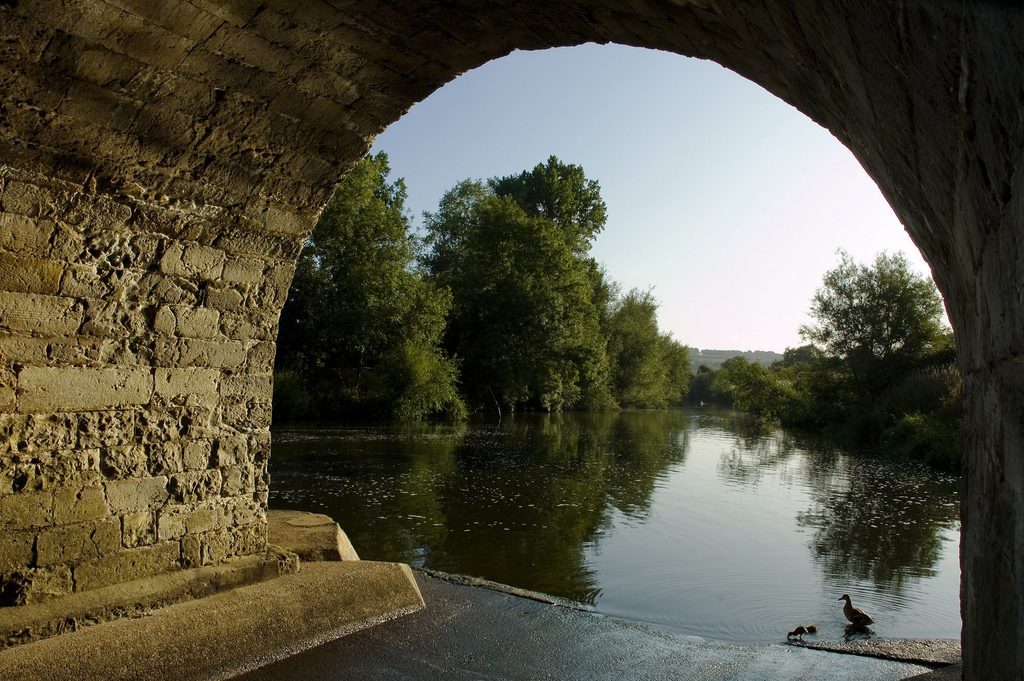
The river is crossed by several mediaeval bridges such as Hawkenbury Bridge, Stephens Bridge and Town Bridge in Yalding. Town Bridge is thought to be the longest Mediaeval Bridge in the county at 450 feet.
The river supports the recreation of course fishing, with several angling clubs leasing or owning sections of the River. The river is pike dominated, although a wide variety of species do occur, particularly further downstream. Upstream of Headcorn angling interests on main river reduce. There are many angling lakes in the catchment, but the tributaries are used sparingly, as they are only minor watercourses.
There are many Public Rights of Way throughout the catchment, but there are no dedicated footpaths or national trails running any significant distance along the main River Beult itself. Some local canoe clubs occasionally use the main river for canoeing activities although there are no navigational rights. Throughout consultation the recreational use and opportunities to expand recreation in the area has been highlighted.
Water Quality
The Beult catchment suffers from high levels of phosphates and low Dissolved Oxygen (DO) levels. These conditions, together with low summer flow and poor habitat range leads to a vegetation dominance of duckweed (Lemna minor) and non-native invasive Water Fern (Azolla filiculoides).
Reduced DO can result from biological oxygen demand from sewage, organic discharges or bacteria, fertilizer runoff and increased water temperature. Phosphates come from waste, laundry and cleaning products, industrial effluents and fertilizer runoff. In turn these phosphates put further demands on oxygen levels further exacerbating weed growth.
Pollution from waste water is a main driver in the water quality condition of the Beult and will be addressed in partnership between the Medway Strategic Group and the water companies.
Channel Form and Profile
Over time the river Beult has been widened and dredged so channel dimensions are now wider and deeper than what would naturally be seen. Especially in the lower reaches of the Beult, below Hawkenbury Bridge, the profile is currently oversized in comparison to the flow regime. In the upper Beult, together with the absence of impoundment, the shallower, narrower sections result in a more dynamic flow. This prevents siltation on the channel bed (© English Nature 2006). The effect of artificial re-profiling has created steep high banks which lack a naturally occurring transitional zone. In areas where the riverbank grades into a natural berm the plant communities are more diverse and support a greater range of associated wildlife. Steep banks may also be a barrier to river use by fauna (© English Nature 2006)
Impoundment and Flow Rate
The clay catchment results in a flashy flow regime, with high flows in winter and very low flows in summer. High flows impact on flood risk whilst low flows impact on river recreation, irrigation and the water availability for stock. Due to this low summer flow sluice boards have been installed to maintain a suitable depth of water. As well as sluice boards, there are seven bridges stretched along the lengths of the main river. Together with sluice boards the bridges, due to changes in the bed level either side of the bridge foundation, have changed flow and impounded the river into compartments which has impacting on fish passage, habitat connectivity, passage of particles and thus an increase in siltation.
Flood Risk Management
The name Beult is of Scandinavian origin and means ‘swollen belly’. This is an apt name since the river regularly overflows its banks with notable flooding in 1776, 1809, 2000 and 2014. The River Beult’s clay catchment means that following rainfall events flows naturally increase substantially, due to limited infiltration to the ground. The floodplain is naturally wide and historically the river used its floodplain many times each year.
The catchment has a low gradient, with the frequent flood events risking properties and people in Smarden, Staplehurst and Headcorn for example. At the confluence of the Rivers Beult, Medway and Teise at Yalding the combination of flows from all three rivers causes significant problems. The Environment Agency has the authority to manage “main river” where necessary, However much of the River Beult catchment falls within the Upper Medway Internal Drainage Board’s drainage district. Adopted watercourses that they regularly manage include the Hammer Stream and River Sherway. Kent County Council (KCC) is the lead local flood authority and has prioritised the Beult catchment as an area subject to local flooding and is working on surface water management plans for Marden, Staplehurst and Headcorn.
The Medway Catchment Flood Management Plan (CFMP) (2009) has the policy of maintaining the existing level of risks from flooding, however since flood events during Winter 2013/14 the Environment Agency now intends to progress flood storage options for the catchment to protect more people and property, this is outlined in the ongoing Medway Flood Storage Areas (FSA’s) Project.
The management of watercourses for flood risk and land drainage purposes has a significant impact on the ecology of the River Beult. It is important that the long term planned management of the river and its tributaries considers all environmental aspects, delivering improved flood resilience to local communities whilst creating a better quality environment.
Habitats and Species
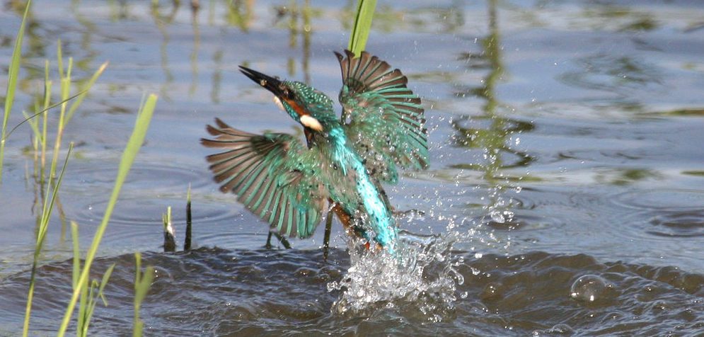
There are over 100 plant species, both emerging and floating throughout the main river Beult in addition to some nationally scarce invertebrate species. Sixteen species of dragonfly have been recorded and common bird species include kingfisher (Alcedo atthis), reed warbler (Acrocephalus scirpaceus) and reed bunting (Emberiza schoeniclus).
The catchment is dominated by modern farming, so whilst there are ancient hedgerows and some ancient woodlands the majority of the catchment is relatively low in biodiversity with few significant stretches of natural habitat. The Beult corridor is included as a Biodiversity Opportunity Area by Kent Wildlife Trust to reflect the area’s potential for biodiversity and highlight that it is currently lacking in wildlife.
Fish
48 fish surveys have been conducted by the Environment Agency between 2001 and 2015. From these surveys it is known that the River Beult is mostly pike (Esox Lucius) dominated with other species including roach (Rutilis rutilis), chub (Leuciscus cephalus), bream (Abramis brama), dace (Leuciscus leuciscus), and gudgeon (Gobio gobio) all recorded. Rudd (Scardinius erythrophthalmus) has also been recorded in places having escaped from on-line fishing lakes.
Site of Special Scientific Interest (SSSI)
The River Beult Site of Special Scientific Interest (SSSI) was designated in 1994 as part of a national series of riverine SSSIs and it is designated from Hadman’s Bridge, Smarden to the confluence with the Medway. Its designation was due to it being representative of a Type II Clay river due to the retention of characteristic flora. Type II rivers are slow-flowing, naturally eutrophic lowland rivers that are dominated by clay substrate. Several marginal and emergent plant species found within the River Beult SSSI are typically more abundant on Type II lowland clay rivers than other river types including Water plantain (Alisma plantago-aquatica) Amphibious bistort (Persicaria amphibian) (pictured below), Celery leaved crowfoot (Ranunculs sceleratus) and Amphibious yellow cress (Rorippa amphibian). The absence of shallow graded banks and wet berms due to historic channel modification currently restricts the distribution and abundance of these species along the River Beult (© Environment Agency 2015)
The two WFD water-bodies that include the SSSI are ‘Beult at Yalding’ and ‘Beult’. The Ecological status of these heavily modified water-bodies is currently ‘moderate’. Failures include phosphates associated with diffuse and point source pollution, dissolved oxygen, fish and phytobenthos (© Environment Agency 2015)
The SSSI is considered in “unfavourable” condition due to a range of issues including; poor dissolved oxygen, lack of fisheries diversity, lack of diverse physical features, high phosphates and poor habitat diversity, poor connectivity of river habitats and processes, the impact of structures, significant modifications to morphology and water quality. These issues are across the Beult catchment and not exclusive to the SSSI location.
Within the Beult Catchment there are two additional SSSI’s, Sissinghurst Park Wood near Hammer Stream and Marden Meadows, which is also a Local Nature Reserve. There are many local wildlife sites, designated by Kent Wildlife Trust. These are non-statutory designations but they compliment designated sites and add to the ecological network at the landscape scale.